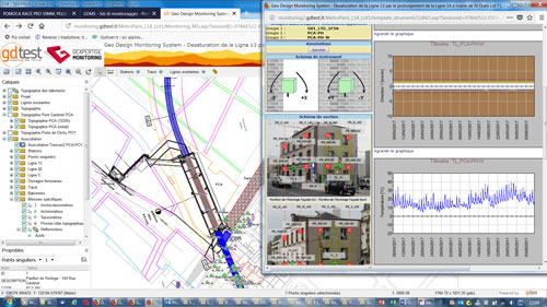

WEB-GIS portal configuration for geotechnical-environmental monitoring and for design support.
Integrated monitoring systems for large works
- Real-time data from automatic sensor collection agents
- Data base unified by equipment instrumentation type
- Measured data processing, alarm control and reporting through dedicated portal
- Comparison of various scenarios to support decision making
- Confidential data access from any device
Informative systems for environmental monitoring
- Automated data collection and integrated document management
- Automatic integration of measuring points in mapping
- Measurement control and managing excess of normative limits
- Specialised thematic dashboards with guidance adapted also to mobile devices
Support for the design of large infrastructure works
- Simulated constructions for feasibility studies
- Management of 3D models of works in progress
- Evaluation of environmental impact
- Project images and survey results
- Building surveys and BRA/BCS analyses